


We owe it all to the sun. It provides the energy that makes life as we know it possible on almost every level, and it’s a critical component in planning your garden. Many plants need the right level of sunlight to thrive, and understanding how the sun moves across your garden over the course of a day is important in ensuring that all your plants stay healthy. So how do you keep track of what the sun does? It may sound like a tall order, but over the years gardeners have developed a tool called a sun map that helps you do just that. By making and using a sun map for your space, you’ll help yourself plan a better garden, work with the seasons more effectively, and get better results over the course of the growing season. So—how do you make a sun map? Let’s dig in!
What is a garden sun map? What does a sun map do?
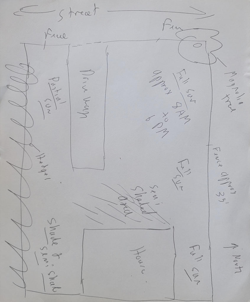
A sun map is just that—a map of your garden or lawn space that shows how much sun various parts of it get over the course of a day. A good sun map will show you what parts of your yard get full sun—sun for 8 hours or more—which parts get partial sun, and which parts are shaded or semi shaded. A sun map is a handy reference, especially when planning a new space. It can help you get to know your garden or yard and to understand the conditions that shape what will grow there.
How do you make a sun map?
There are a few different approaches you can use to make a sun map of your garden. The traditional—maybe even “old fashioned”—approach is to sketch your garden’s layout on a piece of paper. We like to use graph paper for this purpose, as it lets you make more accurate measurements by making each square on the paper equal to one square foot, square yard/meter, or whatever unit of area is appropriate to your space. If you’re comfortable doing so, using a computer-based design, drawing, or graphics program works as well and can make it very easy to update your map as your garden evolves. Regardless of the method you use, there are a few features you should note in your garden map:
- First things first: sketch the overall layout of the property, including where your house, driveway, walkway, and any outbuildings are. Nothing’s more frustrating then laying out a great sun map, picking the perfect spot for your raised beds, and then remembering that there’s already a shed or patio in that spot!
- Don’t forget to indicate directions! North, South, East, and West really do matter!
- Make note of any existing garden features, and plot them out on your map. This includes existing hedges, shrubs, garden beds, and trees. Don’t forget to include the area covered by a tree’s branches—that can affect sun and shade quite a bit!
- While not 100% necessary, while you’re making a sun map it’s helpful to include data about changes in slope or elevation, proximity to the street or roadways near your house, the location of utility lines, and other such data. This can save you time later on and help you keep track of important factors in planning a garden.
Once you have a visual sketch of your garden, be it digital or physical, the next step is to observe the sun over the course of a day. It’s important to do this during your desired growing season—the sun moves higher in the sky in summer and lower in winter, and this can affect how sunlight lands in your garden or yard. We like to take a day, make some coffee or ice tea, and just start watching the garden. Every hour on the hour, walk through the garden and take notes on your sun map as to what parts are in sun, semi-shade, or shade at that time. Pro tip: this is also a great time to just get to know your space by observing what’s already growing, how the drainage works, and what birds/insects/native plants are already thriving.

In this digital world, there’s another approach to making a sun map that isn’t quite as detailed but may appeal to more tech-minded folks. Now that all of our mobile phones have decent cameras built into them, just follow the steps above, spending a day visiting your garden periodically, and take photos as you do. This creates an immediate visual record of where the sun is at that time. If you want to go the extra mile, you can use photo editing software to make a composite photo showing the average sunlight that falls on that space each day. Just make sure you stand in the same place and frame your photos the same way for best results.
Regardless of which method you use to make your sun map, at the end of the day, you’ll have a good set of data to work with. You should know what parts of your garden get sun and how long the sunlight remains there, and then be able to use that data to plan your garden for this season, and beyond.
We hope this article helps you make a sun map of your garden, and that you’re successful in using that map in planting this year’s selection of plants. If you have experience with sun maps in your garden and advice for how to use them, please get in touch. Gardzen is all about community and we love to hear from you!


Leave a comment